Toponauts logo

Toponauts Blog โ€” topografie leren voor kinderen

๐Ÿš To the game โ€” play free at toponauts.com
๐Ÿ‡จ๐Ÿ‡ฑ

๐Ÿ‡จ๐Ÿ‡ฑ New country: fly over Chile!

The driest desert on Earth, the highest active volcano in the world, and Easter Island way out in the Pacific โ€” Chile has landed in Toponauts!

Buckle up your seatbelt โ€” Toponauts is flying to the longest, skinniest country in the world: Chile! ๐Ÿ‡จ๐Ÿ‡ฑโœˆ๏ธ It stretches an incredible 4,300 kilometres from the driest desert on Earth all the way down to icy glaciers near Antarctica. Fly over its 16 regiones, the towering Andes, and even one of the most remote islands on the planet!

๐Ÿ—บ๏ธ 16 regiones, one very long country

Chile is divided into 16 regiones, each with its own capital city โ€” from sun-baked Arica in the far north to windswept Punta Arenas near the tip of South America. The country's capital, Santiago, sits right in the middle in the Regiรณn Metropolitana. Fly into each regione and watch its real border light up on the map!

๐Ÿœ๏ธ The driest place on Earth

In the north of Chile lies the Atacama Desert โ€” the driest desert in the whole world. Some parts have never recorded a single drop of rain! Despite the dryness, this is where you'll find the mighty Rรญo Loa, Chile's longest river at 440 km, winding through the sand on its way to the Pacific Ocean.

๐ŸŒ‹ Ojos del Salado โ€” the highest volcano on Earth

Running along almost the entire length of Chile are the mighty Andes mountains. Hidden among them is Ojos del Salado, standing an incredible 6,893 metres tall โ€” it's not just Chile's tallest peak, it's the highest active volcano anywhere on Earth! Chile has more than 600 volcanoes in total, including famous ones like Villarrica and Osorno, which still smoke and rumble today.

๐ŸŒŠ Rivers from the mountains to the sea

Chilean rivers rush down from the Andes in the east to the Pacific Ocean in the west. Near the capital, the Rรญo Maipo flows past Santiago, while further south the powerful Rรญo Biobรญo carries more water than any other river in the country โ€” it was once even the border between the Chilean state and the Mapuche people's land.

๐Ÿ—ฟ Easter Island โ€” the loneliest island in the world

Way out in the Pacific Ocean, more than 3,500 km from the Chilean coast, lies Isla de Pascua โ€” also known as Easter Island or Rapa Nui. It's the most remote inhabited island on Earth, famous for its giant stone statues called moai. Even further out you'll find the tiny Juan Fernรกndez Islands, once home to the real-life castaway who inspired the story of Robinson Crusoe!

๐ŸŽ‰ Fun facts

  • Chile shares borders with 3 countries: Peru, Bolivia and Argentina โ€” the border with Argentina alone is over 5,300 km long, almost entirely along the top of the Andes.
  • Chile is so long that it has 5 very different zonas naturales โ€” from scorching desert in the north to fjords and glaciers in the far south.
  • The newest regione, ร‘uble, was only created in 2018 โ€” before that it was part of the Biobรญo region.
  • Chile stretches across such a huge range of latitude that flying from the top to the bottom is a bit like flying from the Sahara Desert all the way to Antarctica!

โ–ถ๏ธ How to play

Switch your country to Chile with the "change your country" button, then pick a map โ€” regiones, capitals, big cities, rivers, mountains, lakes or islands. Zoom into a single regione to practise its towns. ยกBuen vuelo! ๐Ÿš

Read more โ†’
๐Ÿ‡ฒ๐Ÿ‡ฆ

๐Ÿ‡ฒ๐Ÿ‡ฆ New country: fly over Morocco!

12 regions, a desert, two seas, and a mountain so tall it wears snow above the Sahara โ€” Morocco has landed in Toponauts!

Pack your bags โ€” Toponauts is flying to North Africa to explore Morocco! ๐Ÿ‡ฒ๐Ÿ‡ฆโœˆ๏ธ It's a country with two different coastlines, a mighty mountain range with snow on top, and the edge of the world's biggest hot desert. Fly over its 12 regions, its winding rivers, and its highest peak, and find out why the capital city isn't even the biggest one!

๐Ÿ—บ๏ธ 12 regions, one for every corner

Morocco is divided into 12 regions, each with its own regional capital. Fly over all of them, then zoom into a single region to practise the towns inside it! Here's a fun surprise: the country's official capital is Rabat, but it isn't Morocco's biggest city at all โ€” that title goes to Casablanca, the huge port city on the Atlantic coast. Other famous regional capitals include Marrakech (nicknamed "the Red City" for its clay-coloured walls), Fรจs (home to one of the oldest, maziest old towns in the world), and Tanger, the gateway city where Africa almost touches Europe.

โ›ฐ๏ธ Toubkal, the roof of North Africa

Running right through the middle of the country is the Atlas Mountains, split into three chains: the High Atlas, the Middle Atlas, and the Anti-Atlas. In the High Atlas stands Toubkal, which at 4,167 metres is the highest mountain in Morocco โ€” and in all of North Africa! It's tall enough to stay capped in snow for part of the year, even though it's not that far from the hot Sahara desert. Up along the Mediterranean coast there's a second, smaller mountain range too: the Rif.

๐ŸŒŠ Rivers that shape the land

Morocco's rivers travel in every direction. The Sebou and Oum Er-Rbia are the country's two longest "always-flowing" rivers, watering the farmland plains near the Atlantic coast. The Draa is Morocco's longest river of all โ€” it flows south from the mountains towards the Sahara, but its lower stretch often dries up completely in the desert heat! And the Moulouya is special because it's the only major Moroccan river that flows all the way to the Mediterranean Sea instead of the Atlantic Ocean.

๐Ÿœ๏ธ Two seas, one desert, and ancient medinas

Morocco is one of the few countries in the world with coastlines on two different seas: the Atlantic Ocean in the west and the Mediterranean Sea in the north. At the narrow Strait of Gibraltar, Morocco and Spain are only about 14 kilometres apart! Down in the south and east, the land turns into the golden dunes of the Sahara desert, where camel caravans still cross the sand. And in its old cities, Morocco is famous for its medinas โ€” historic walled old towns full of narrow, twisting streets, colourful souk markets, and centuries-old buildings.

๐ŸŽ‰ Fun facts

  • Morocco has 9 UNESCO World Heritage Sites, including the ancient medinas of Fรจs and Marrakech and the clifftop village of Aรฏt Ben Haddou, famous for its mud-brick towers.
  • Three languages share the streets in Morocco: Arabic and Tamazight (Berber) are both official languages, and French is widely used too โ€” so a Moroccan street sign might greet you in all three!
  • Morocco isn't just desert โ€” it also grows some of the world's best oranges, olives and argan oil, a golden oil made only from the nuts of a tree that grows almost nowhere else on Earth.
  • The word "Marrakech" gave Morocco its name in many languages around the world โ€” even though Marrakech itself is just one of many Moroccan cities!

โ–ถ๏ธ How to play

Switch your country to Morocco with the "change your country" button, then pick a map โ€” regions, capitals, big cities, rivers or mountains. Zoom into a single region to practise its towns. Happy flying! ๐Ÿš

Read more โ†’
๐Ÿ‡น๐Ÿ‡ญ

๐Ÿ‡น๐Ÿ‡ญ New country: fly over Thailand!

77 provinces, temples, elephants, and a river born from four rivers meeting โ€” Thailand has landed in Toponauts!

Grab your wings โ€” Toponauts is flying to Southeast Asia for the very first time: Thailand! ๐Ÿ‡น๐Ÿ‡ญโœˆ๏ธ It's a country of golden temples, jungle mountains, and a long, curvy coastline on two different seas. Fly over its 77 provinces, its mighty rivers, and its tallest mountain, and discover why almost every Thai province is named after its own capital city.

๐Ÿ—บ๏ธ 77 provinces, one for every corner

Thailand has 76 provinces (changwat) plus the capital Bangkok, which is its own special governed area โ€” together that's 77 places to fly into! Thai schoolkids learn them grouped into 6 regions: the mountainous North, the vast Northeast (called Isan), the Central plains around Bangkok, the East coast, the West near Myanmar, and the tropical South stretching all the way down towards Malaysia.

๐Ÿ›๏ธ A neat naming trick โ€” and one very long name

Here's a fun shortcut for learning Thai geography: almost every province is named after its own capital city! Chiang Mai province has its capital in Chiang Mai, Phuket province's capital is Phuket, and so on โ€” nearly all 76 match perfectly. Bangkok is the big exception, and it hides an amazing secret: its full ceremonial name is over 170 letters long โ€” Krung Thep Mahanakhon Amon Rattanakosin... and much, much more โ€” making it the longest official city name in the world! Locals simply call it Krung Thep, "City of Angels".

๐ŸŒŠ Four rivers become one

Thailand's most important river, the Chao Phraya, doesn't start as one river at all โ€” it's born when four rivers (the Ping, Wang, Yom and Nan) flow together at the city of Nakhon Sawan! From there the Chao Phraya winds south through rice fields all the way to Bangkok before reaching the sea. In the northeast, the Mekong forms the long, curling border with Laos, while the Mun and Chi rivers cross the Isan region on their way to join it.

โ›ฐ๏ธ Doi Inthanon, the roof of Thailand

Up in the misty mountains near Chiang Mai stands Doi Inthanon, Thailand's highest point at 2,565 metres โ€” locals call it "the roof of Thailand". It's part of a mountain chain that runs along the border with Myanmar, and it's so high up that it's one of the few places in Thailand that ever gets close to frost!

๐ŸŽ‰ Fun facts

  • Thailand used to be called Siam until 1939 โ€” you might still spot the old name in books and museums.
  • The elephant is Thailand's beloved national animal, and it appears on temples, flags and coins throughout the country's history.
  • Watch out for tricky letter combos: "ph" sounds like a puffy p (Phuket โ‰ˆ "Poo-ket", not "Foo-ket"), and "th" sounds like a puffy t (Thailand โ‰ˆ "T-hai-land") โ€” never like the English "th"!
  • Thailand has 8 UNESCO World Heritage Sites, including the ancient ruined cities of Ayutthaya and Sukhothai โ€” both were once capitals of Thailand, hundreds of years before Bangkok.

โ–ถ๏ธ How to play

Switch your country to Thailand with the "change your country" button, then pick a map โ€” provinces, regions, capitals, big cities, rivers, mountains or lakes. Zoom into a single province to practise its towns. Happy flying! ๐Ÿš

Read more โ†’
๐Ÿ‡ณ๐Ÿ‡ฟ

๐Ÿ‡ณ๐Ÿ‡ฟ New country: fly over New Zealand!

16 regions, two big islands, the mighty Waikato River, and the towering Southern Alps โ€” New Zealand has landed in Toponauts!

Pack your wings โ€” Toponauts is flying all the way to the bottom of the world: New Zealand! ๐Ÿ‡ณ๐Ÿ‡ฟโœˆ๏ธ Kiwis call it Aotearoa, "the land of the long white cloud", and it's made of two big islands (plus a few smaller ones) sitting all alone in the huge Pacific Ocean. Explore its 16 regions, its snowy mountains, and its rivers that wind from lake to sea.

๐Ÿ—บ๏ธ 16 regions on two islands

New Zealand is divided into 16 regions: 9 on the North Island (Te Ika-a-Mฤui) and 7 on the South Island (Te Waipounamu). Fly into each one and watch its real border light up on the map โ€” from busy Auckland (the biggest region) to wild, empty West Coast on the South Island, where more sheep live than people!

๐Ÿ›๏ธ One country, two names for everything

Almost every place in New Zealand has both an English name and a Mฤori name โ€” sometimes both official names are even joined together, like the country's highest mountain: Aoraki / Mount Cook. Auckland's Mฤori name is Tฤmaki-makau-rau, and Christchurch is ลŒtautahi. The capital city, Wellington, sits right where the North and South Islands almost touch, on the Cook Strait.

๐ŸŒŠ Rivers from mountain to sea

The Waikato River is New Zealand's longest river โ€” it starts at Lake Taupล (the country's biggest lake, sitting inside a giant ancient volcano!) and flows about 425 km north to the Tasman Sea. On the South Island, the fast-flowing Clutha River (also called Mata-Au) carries more water than any other river in the country, tumbling down from the mountains near Lake Wanaka.

โ›ฐ๏ธ The Southern Alps and Aoraki

Down the whole length of the South Island run the Southern Alps โ€” a long, jagged mountain chain the Mฤori call Kฤ Tiritiri o te Moana. Right in the middle stands Aoraki / Mount Cook, New Zealand's highest peak at 3,724 metres. Up on the North Island, keep an eye out for smoking volcanoes: Ruapehu, Tongariro and Taranaki (also called Mount Egmont) are all still active!

๐ŸŽ‰ Fun facts

  • New Zealand was one of the last places on Earth that people settled โ€” the first Polynesian voyagers (the ancestors of the Mฤori) only arrived around 700 years ago.
  • It's home to the kiwi, a fluffy flightless bird that can't fly and lays enormous eggs โ€” and it's also the nickname New Zealanders give themselves!
  • New Zealand has no snakes at all living in the wild โ€” it's one of the very few countries in the world without them.
  • Big cities to discover include Auckland, Wellington, Christchurch, Hamilton and Tauranga โ€” and don't forget Stewart Island, a wild third island way down south.

โ–ถ๏ธ How to play

Switch your country to New Zealand with the "change your country" button, then pick a map โ€” regions, capitals, big cities, rivers, relief or lakes. Zoom into a single region to practise its towns. Happy flying! ๐Ÿš

Read more โ†’
๐Ÿ‡ฟ๐Ÿ‡ฆ

๐Ÿ‡ฟ๐Ÿ‡ฆ New country: fly over South Africa!

9 provinces, 3 capital cities, the mighty Orange River, and Table Mountain โ€” South Africa has landed in Toponauts!

Get your hiking boots ready โ€” Toponauts is heading to the southern tip of Africa: South Africa! ๐Ÿ‡ฟ๐Ÿ‡ฆโœˆ๏ธ It's a huge country with three very different landscapes: sunny beaches, wide golden grassland, and even snow-capped mountains. Fly over its 9 provinces, big rivers, and famous landmarks like Table Mountain.

๐Ÿ—บ๏ธ 9 provinces to explore

South Africa is divided into 9 provinces: Gauteng, Western Cape, Eastern Cape, KwaZulu-Natal, Free State, Limpopo, Mpumalanga, North West and Northern Cape. Fly into each one and watch its real border light up on the map โ€” from busy Gauteng (the smallest province, but the most crowded) to the huge, dry Northern Cape.

๐Ÿ›๏ธ Not one, not two, but THREE capital cities!

Here's a fun surprise: South Africa doesn't have just one capital city โ€” it has three! Pretoria is where the government works, Cape Town (Kaapstad) is where parliament meets and makes the laws, and Bloemfontein is where the country's top judges decide on court cases. No other country in the world splits its capital like this!

๐ŸŒŠ Rivers across the land

The Orange River is South Africa's longest river โ€” it starts high up in the mountains of Lesotho and flows all the way west to the Atlantic Ocean. Its biggest helper is the Vaal River, which supplies water to millions of people around Johannesburg. Up north, the Limpopo river forms a natural border with Botswana and Zimbabwe.

โ›ฐ๏ธ From Table Mountain to the Drakensberg

Right behind Cape Town rises the flat-topped Table Mountain, one of the most recognisable mountains on Earth โ€” sometimes it even gets covered by a cloud that looks like a tablecloth! Further east, the jagged Drakensberg ("Dragon Mountains") rise up to 3,450 metres at their highest point, Mafadi, right on the border with Lesotho.

๐ŸŽ‰ Fun facts

  • South Africa completely surrounds another country: tiny Lesotho sits entirely inside its borders, like a hole in a donut!
  • The country has 11 official languages โ€” more than almost any other country in the world.
  • South Africa is home to the Cape Floral Region, a small area with more plant species than the whole of the UK.
  • Big cities to discover include Johannesburg, Durban, Gqeberha (Port Elizabeth) and Kimberley โ€” once famous for its giant diamond mine.

โ–ถ๏ธ How to play

Switch your country to South Africa with the "change your country" button, then pick a map โ€” provinces, capitals, big cities, rivers or landscapes. Zoom into a single province to practise its towns. Happy flying! ๐Ÿš

Read more โ†’
๐Ÿ‡ฆ๐Ÿ‡ท

๐Ÿ‡ฆ๐Ÿ‡ท New country: fly over Argentina!

24 provinces, the mighty Andes, Aconcagua the giant, and the wide Rรญo de la Plata โ€” Argentina has landed in Toponauts!

Pack your poncho โ€” Toponauts is heading south, all the way to Argentina! ๐Ÿ‡ฆ๐Ÿ‡ทโœˆ๏ธ It's one of the biggest countries in South America, stretching from steamy jungles in the north to icy glaciers in the far south. Fly over its 24 provincias, the giant Andes mountains, wide rivers and Patagonian lakes.

๐Ÿ—บ๏ธ 24 provincias, one very special city

Argentina is divided into 23 provincias plus one extra-special place: the Ciudad Autรณnoma de Buenos Aires (CABA) โ€” the capital city, which is its own province all by itself! Don't mix it up with provincia de Buenos Aires next door, whose capital is actually La Plata. Fly into each provincia and watch its real border light up โ€” from tiny Tucumรกn in the north to giant Santa Cruz in the frosty south.

โ›ฐ๏ธ Aconcagua โ€” the roof of the Americas

Along the whole western edge of Argentina rise the mighty Andes, the longest mountain range on Earth. Hidden among them is Aconcagua, standing 6,961 metres tall โ€” the highest mountain in the Americas AND in the whole Southern and Western Hemisphere! Climbers from all over the world come to try to reach its icy summit.

๐ŸŒŠ Rivers that never stop

The enormous Paranรก river flows down from Brazil, joined by the Uruguay, before both pour into the giant Rรญo de la Plata โ€” so wide near Buenos Aires that it looks more like a sea than a river! Down south, the Colorado and Negro rivers cross the dry Patagonian plains on their way to the Atlantic Ocean.

๐Ÿž๏ธ Icy lakes of Patagonia

In the far south, near the border with Chile, you'll find glacier-fed lakes with brilliant turquoise water โ€” like Nahuel Huapi, ringed by snowy peaks, and Lago Argentino, fed by melting glaciers. All the way at the bottom of the country lies Tierra del Fuego ("Land of Fire") โ€” the southernmost tip of South America, right across the water from Antarctica!

๐ŸŽ‰ Fun facts

  • Argentina shares a border with 5 countries: Chile, Bolivia, Paraguay, Brazil and Uruguay.
  • The border with Chile runs 5,308 km โ€” almost entirely along the top of the Andes!
  • Buenos Aires and its surroundings (Gran Buenos Aires) are home to more than 10 million people โ€” almost a quarter of the whole country.
  • Argentina stretches so far โ€” from about 22ยฐS to 55ยฐS โ€” that it has jungle in the north and icy glaciers in the south, all in one country.

โ–ถ๏ธ How to play

Switch your country to Argentina with the "change your country" button, then pick a map โ€” provincias, capitals, big cities, rivers or lakes. Zoom into a single provincia to practise its towns. ยกBuen vuelo! ๐Ÿš

Read more โ†’
๐Ÿ‡บ๐Ÿ‡ฆ

๐Ÿ‡บ๐Ÿ‡ฆ New country: fly over Ukraine!

26 July 2026

27 regions, the mighty Dnipro, the Carpathian Mountains and the historic cities of Kyiv, Lviv and Odesa โ€” Ukraine has landed in Toponauts!

Pack your sunflowers โ€” Toponauts flies east! ๐Ÿ‡บ๐Ÿ‡ฆ๐ŸŒป Ukraine is our newest country to explore, with its regions, its great rivers and its famous cities.

๐Ÿ—บ๏ธ 27 regions, one capital

Ukraine is divided into 24 oblasts, plus the Autonomous Republic of Crimea and the special-status cities of Kyiv (the capital) and Sevastopol โ€” 27 regions in total, matching the borders taught in Ukrainian schools. Fly into each one โ€” from Lviv in the west to Kharkiv in the east โ€” and its real border lights up when you're inside!

๐ŸŒŠ Rivers to the Black Sea

The mighty Dnipro cuts the country in two on its long journey from north to south, joined by the Dnister in the west and the Southern Bug and Siverski Donets in the east. Even the famous Danube touches Ukraine's southwestern corner on its way to the Black Sea.

โ›ฐ๏ธ Mountains in the far west

Most of Ukraine is flat farmland, but in the far west the Carpathian Mountains rise up, home to Hoverla (2,061 m) โ€” the country's highest peak. Down south, the Crimean Mountains hug the coastline.

โ–ถ๏ธ How to play

Switch your country to Ukraine with the "change your country" button, then pick a map โ€” regions, capitals, rivers or mountains. Zoom into a single oblast to practise its towns. Ready? ะ’ะฟะตั€ะตะด! (Forward!) ๐Ÿš

Read more โ†’
๐Ÿ‡ฆ๐Ÿ‡น

๐Ÿ‡ฆ๐Ÿ‡น New country: fly over Austria!

Nine federal states, the mighty Alps, the blue Danube and Alpine lakes โ€” Austria has landed in Toponauts!

Grab your climbing boots โ€” Toponauts is heading into the Alps! ๐Ÿ‡ฆ๐Ÿ‡นโ›ฐ๏ธ Austria is our newest country to explore, with all 9 federal states, the biggest cities, the great rivers and the famous Alpine lakes.

๐Ÿ—บ๏ธ Nine states, nine capitals

Austria is a federal country made up of nine Bundeslรคnder, each with its own capital โ€” from Vienna (Wien), which is a city and a state at once, to Tyrol with its mountain capital Innsbruck, sunny Carinthia (Klagenfurt) and tiny Vorarlberg in the far west (Bregenz). Fly into each state โ€” its real border lights up when you're inside!

โ›ฐ๏ธ The Alps rule

Around 62% of Austria is covered by the Alps. You'll find mountain groups like the Hohe Tauern โ€” home to the GroรŸglockner (3,798 m), Austria's highest peak โ€” plus the Karwendel, the Dachstein and the Karawanken along the southern border.

๐ŸŒŠ Rivers and lakes

The Danube (Donau) flows west-to-east across the north, joined by the Inn, Salzach, Enns, Drau and Mur. And don't miss the lakes: the reedy Neusiedler See in the east, the deep Attersee and Wรถrthersee, and Lake Constance (Bodensee) shared with Germany and Switzerland.

โ–ถ๏ธ How to play

Switch your country to Austria with the "change your country" button, then pick a map โ€” states, capitals, rivers, mountains or lakes. Zoom into a single Bundesland to practise its towns. Ready? Auf geht's! ๐Ÿš

Read more โ†’
๐Ÿ‡ฎ๐Ÿ‡น

๐Ÿ‡ฎ๐Ÿ‡น Toponauts now speaks Italian!

The whole game โ€” and hundreds of practice maps โ€” are now available in Italian. Benvenuti, piccoli esploratori!

Big news for our Italian friends โ€” and for anyone learning Italian: Toponauts is now fully playable in Italian! ๐Ÿ‡ฎ๐Ÿ‡น From the menus and buttons to the hundreds of map descriptions, the whole game now speaks Italian too. Benvenuti a bordo!

๐Ÿ—บ๏ธ The whole game, in your language

Italy has been a Toponauts country for a while โ€” you can already fly over all 20 regioni, find the capitals, trace the rivers and spot the volcanoes. But until now, Italian children had to play in another language. Not anymore! Every screen, every hint and every list name is translated: Regioni d'Italia, Grandi cittร , Fiumi, Montagne โ€” it all reads naturally in Italian.

๐ŸŒ Six languages, one map of the world

With Italian, Toponauts now speaks six languages: Dutch, English, Spanish, French, German and Italian. Switch anytime with the ๐ŸŒ button โ€” the game remembers your choice. And it's not just the buttons: the learning pages for every map (from Regioni d'Italia to the States of the USA) now exist in Italian too, so you can discover the whole world in your own language.

๐Ÿงญ A fun way to learn Italian, too

Not Italian? Switching the language is a playful way to pick up new words. You already know the map, so you can guess what capitali, fiumi and montagne mean โ€” geography and language in one flight.

โ–ถ๏ธ How to play in Italian

Tap the ๐ŸŒ language button and choose Italiano. That's it โ€” hop in the helicopter and start exploring. Every map, from your own country to the whole world, is ready and waiting. Buon volo! ๐Ÿš

Read more โ†’

๐Ÿ๏ธ New: fly the Canary Islands โ€” Spain's volcanic archipelago!

20 juli 2026

Seven volcanic islands, one giant map! Explore Mount Teide, Timanfaya, and the cities and national parks of the Canary Islands โ€” all in a single new Toponauts map.

Pack your sunscreen โ€” Toponauts is heading to a very special place: the Canary Islands! ๐Ÿ๏ธ๐ŸŒ‹ This brand-new map lets you explore all 7 volcanic islands, their biggest cities, famous volcanoes, and national parks โ€” all in one flight.

๐Ÿ๏ธ Seven islands, one archipelago

The Canary Islands belong to Spain, but they're not in Europe at all โ€” they float in the Atlantic Ocean, right off the coast of Africa! There are seven main islands: Tenerife, Gran Canaria, Fuerteventura, Lanzarote, La Palma, La Gomera and El Hierro. Most of them now have their real coastline drawn on the map, so you can fly right along their shores.

๐ŸŒ‹ Born from fire

Every single Canary Island was made by volcanoes! The tallest one, Mount Teide on Tenerife, is Spain's highest mountain at 3,715 metres โ€” and it's still an active volcano. On Lanzarote you'll find Timanfaya, a landscape so fiery and bare it looks like the surface of the Moon. And on La Palma, Volcรกn de Tajogaite erupted as recently as 2021, creating brand-new black-sand beaches.

๐ŸŒณ Wild and protected

Four of the islands' most special places are national parks: Teide, Timanfaya, Garajonay (an ancient misty forest on La Gomera) and the Caldera de Taburiente, a giant volcanic crater on La Palma so big you could almost fit a whole city inside it.

๐Ÿ™๏ธ Cities by the sea

Fly into Santa Cruz de Tenerife and Las Palmas de Gran Canaria, the two biggest cities โ€” together they even share the job of being the region's capital! Along the way you'll pass La Laguna, Arrecife and other island towns.

๐Ÿ’ก Did you know?

  • The Canary Islands are named after dogs, not birds! The Latin name Insulae Canariae means "Islands of the Dogs."
  • El Hierro is so far west that, centuries ago, mapmakers used it as the starting point โ€” longitude zero โ€” before Greenwich took over.
  • Teide's peak is often capped with snow in winter, even though the islands feel like summer almost all year round.

๐Ÿš How to play

Open the Canary Islands map from Spain and pick your target: fly onto an island's coastline, into a volcano, or straight to a city. Some islands and volcanoes have their real outline โ€” cross into it and you've found it! Ready for takeoff? ๐Ÿš๐ŸŒ‹

Read more โ†’

๐ŸŽฏ Find the whole area, not just a dot

18 juli 2026

How do you 'find' a whole sea or a mountain range? Toponauts now checks whether your helicopter is INSIDE the real shape. Here's the clever little idea behind it.

Finding a city is easy: fly to the dot. But how do you find a whole sea, a mountain range or a lake? They're not dots โ€” they're big areas. Toponauts now has a clever answer. ๐ŸŽฏ

๐Ÿ—บ๏ธ Areas, not points

Every sea, lake, region and mountain range now has its own real outline stored in the game. Instead of asking "are you close to the middle?", Toponauts asks "are you inside the shape?" The instant you cross the coastline of the Mediterranean or the edge of the Alps, you've found it.

๐Ÿงฎ The clever trick

Computers check this with a neat idea called point-in-polygon: draw an imaginary line from your helicopter out to the edge of the world and count how many times it crosses the border of the shape. An odd number of crossings means you're inside; an even number means you're outside. Simple, fast, and it works for any wobbly coastline!

๐ŸŒŠ Even oceans with many pieces

Some oceans, like the Atlantic and the Pacific, are split across the globe into several pieces. The game now checks all the pieces at once, so you can find the Pacific whether you're near Japan or near Chile.

๐ŸŽ“ Why it's better for learning

Flying into a place feels more real than tapping a dot. You experience how big the Sahara is, how long the Andes stretch, how the North Sea hugs the coast. That sense of size and place is exactly what sticks in your memory.

๐Ÿš How to play

Just play any map with seas, lakes, regions or mountains. On easy levels the outline is shown; on harder levels it fades, so you fly on what you know. Find the whole world โ€” one area at a time! ๐ŸŽฏ๐Ÿš

Read more โ†’
๐ŸŽจ

๐ŸŽจ A colour-coded world: water, mountains and land

16 July 2026

A small change that makes a big difference: areas on the map now have a natural colour. Water is blue, mountains are brown, land and nature are green โ€” so you can read the map at a glance.

Sometimes a small tweak makes the whole game clearer. From now on, every area you fly into has a natural colour, so you can read the map in a heartbeat. ๐ŸŽจ

๐ŸŒˆ What the colours mean

  • ๐Ÿ’ง Blue โ€” water: lakes, seas and oceans.
  • โ›ฐ๏ธ Brown โ€” mountain ranges.
  • ๐ŸŒณ Green โ€” land: countries, regions, provinces and nature areas.

Rivers stay water-blue lines, just like before. It's the same colour code mapmakers and atlases have used for hundreds of years โ€” so it feels familiar straight away.

๐Ÿง  Why colour helps you learn

Our brains remember pictures far better than words. When a lake glows blue and the Alps turn brown, your memory links the place to the kind of place it is. That makes it easier to recall later โ€” colour is a quiet little learning trick.

๐Ÿ’ก Did you know?

On almost every map in the world, water is blue and high mountains are brown. It's such a strong habit that when mapmakers once printed land in unusual colours for fun, people found the maps almost impossible to read!

๐Ÿš How to play

Nothing to switch on โ€” just play any map with regions, lakes or mountains and you'll see the new colours right away. Fly safe! ๐ŸŽจ๐Ÿš

Read more โ†’

๐Ÿž๏ธ Lakes of France and the UK โ€” including Lac Lรฉman

14 juli 2026

Two new lake maps! Glide across Lac Lรฉman and the lakes of the French Alps, or go island-hopping over Loch Ness, Loch Lomond and Lake Windermere.

Splash down on the water โ€” Toponauts has two new lake maps: the Lakes of France and the Lakes of the United Kingdom. ๐Ÿž๏ธ๐Ÿš

๐Ÿ‡ซ๐Ÿ‡ท The lakes of France

France's biggest lakes hide in the Alps. Glide across Lac Lรฉman (also called Lake Geneva, shared with Switzerland), Lac d'Annecy โ€” one of the cleanest lakes in Europe โ€” Lac du Bourget, the reservoir Serre-Ponรงon, and the lagoon-like ร‰tang de Berre near Marseille.

๐Ÿ‡ฌ๐Ÿ‡ง The lochs and lakes of Britain

Scotland calls its lakes lochs. Fly over the legendary Loch Ness, the long and lovely Loch Lomond, Loch Awe and Loch Tay. In England you'll find Windermere, the country's largest natural lake, and over in Northern Ireland the huge Lough Neagh.

๐Ÿ’ก Did you know?

  • Loch Ness holds more fresh water than all the lakes of England and Wales put together โ€” and, of course, a famous legend.
  • Lac Lรฉman is shaped like a giant croissant and is the largest lake in Western Europe.
  • Lough Neagh is the biggest lake in the British Isles.

๐Ÿš How to play

Choose France or the UK and pick the lakes map. Each lake is drawn as its real shape on the water โ€” fly onto it to find it. Try to learn them all without the outline switched on!

Read more โ†’

โ›ฐ๏ธ Fly through the mountains of the world

12 juli 2026

Mountain ranges are huge areas, not single dots โ€” so now they have a real shape. Fly INTO the Alps, the Pyrenees, the Pennines or the Appalachians and you've found them.

A mountain range isn't one spot on the map โ€” it's a giant wall of peaks stretching for hundreds of kilometres. So in Toponauts, ranges now have a real shape you can fly straight into. ๐Ÿšโ›ฐ๏ธ

๐Ÿ—บ๏ธ Ranges across every country

We drew smooth outlines for mountain ranges all over the world. Cross into the Alps or Pyrenees, Germany's Black Forest and Harz, Spain's Sierra Nevada and Cantabrian Mountains, Britain's Pennines, Cairngorms and Snowdonia, Italy's Apennines, or the mighty Appalachians in the USA โ€” and the game knows you're there.

๐Ÿ”๏ธ Peaks stay as points

Some famous mountains are a single summit, not a whole range โ€” like Ben Nevis in Scotland or El Teide in Spain. Those stay as one spot to aim for, because a peak really is one place. Ranges are areas; summits are points.

๐Ÿ’ก Did you know?

  • The Alps stretch across eight countries and are still slowly growing taller.
  • The Appalachians in North America are among the oldest mountains on Earth โ€” older than the bones of any dinosaur.
  • The Pyrenees form a natural wall between France and Spain, with the tiny country of Andorra hidden in the middle.

๐Ÿš How to play

Pick a country and choose its mountains, then fly toward the range. The moment you're inside the outline, you've found it. On easier levels the shape is drawn for you; on harder levels it disappears and you fly on knowledge alone. Onward and upward! โ›ฐ๏ธ

Read more โ†’

๐ŸŒณ Discover the nature and rivers of every region

10 juli 2026

Zoom into any region and you'll find more than cities now: its rivers and lakes, and its national parks and nature areas. Every French rรฉgion, German Bundesland and Italian regione comes alive.

Zoom into a region in Toponauts โ€” a French rรฉgion, a German Bundesland, an Italian regione โ€” and you'll find a lot more to explore than before. Next to the cities and villages, every region now also has its own rivers & lakes and its nature areas & national parks. ๐ŸŒณ๐Ÿž๏ธ

๐Ÿž๏ธ Rivers & lakes of your region

Pick a region and choose Rivers & lakes. You'll see exactly which famous rivers flow through it: the Seine through Normandy, the Danube and Main through Bavaria, the Po and Arno through northern Italy. A river isn't tied to one spot โ€” it threads through every region it crosses, so you learn where it travels.

๐ŸŒฒ Nature & national parks

Choose Nature areas and discover the protected wild places of each region โ€” from France's Cรฉvennes and Camargue to Germany's Black Forest parks, Italy's mountain reserves and the great national parks of the United States. These are real, protected landscapes where nature comes first.

๐Ÿงญ How we built it

For the rivers, the game checks which regions each river actually flows through and lists it there. For nature, we used real national parks and protected areas from open map data โ€” no made-up places. Some city-regions (like Berlin or Brussels) have little wild nature, so they simply show fewer entries: honest, just like the real world.

๐Ÿ’ก Did you know?

  • The United States has more than 60 national parks โ€” Yellowstone, in 1872, was the very first national park in the world.
  • France's Cรฉvennes park is so dark at night that it's an official "International Dark Sky Reserve" โ€” perfect for stargazing.
  • A single river like the Danube can pass through many regions and even ten countries on its way to the sea.

๐Ÿš How to play

Open any country, fly into a region, and pick the category you want: cities, villages, rivers & lakes, or nature. Mix them for a full tour of what makes each region special. Happy exploring! ๐ŸŒณ

Read more โ†’

๐ŸŒŠ Sail every sea: 53 seas and oceans to explore

8 juli 2026

Toponauts now has a complete seas + oceans map: all five oceans plus 48 famous seas, from the Caribbean to the Coral Sea. Fly across the globe and learn them all.

Grab your helicopter โ€” there's a whole planet of water to explore! ๐Ÿš๐ŸŒŠ Toponauts now has a brand-new world map: Seas & oceans of the world, with 53 bodies of water to find. That's all five oceans plus 48 of the most famous seas, gulfs and bays on Earth.

๐ŸŒ The five oceans

Every drop of seawater belongs to one of the five oceans: the huge Pacific and Atlantic, the warm Indian Ocean, the icy Arctic Ocean around the North Pole, and the Southern Ocean circling Antarctica. In Toponauts you don't just point at them โ€” you fly right into them.

๐Ÿ๏ธ Seas big and small

A sea is a smaller part of an ocean, usually closer to land. You'll find the Mediterranean tucked between Europe and Africa, the Caribbean with its islands, the Red Sea, the Black Sea, the Coral Sea by Australia, the Bering Sea between Russia and Alaska, and dozens more.

๐Ÿ’ก Did you know?

  • The Pacific Ocean is bigger than all the land on Earth combined.
  • The Caspian Sea is the largest enclosed water in the world โ€” a sea with no link to an ocean.
  • The Sargasso Sea has no coast at all: its borders are ocean currents.
  • The Mediterranean connects to the Atlantic through one narrow gap โ€” the Strait of Gibraltar.

๐Ÿš How to play

Open Seas & oceans of the world from the world map and start flying. The moment your helicopter crosses into a sea, you've found it! On easy levels the shape is shown clearly; on harder levels it fades, so you have to know where to go. Perfect for budding explorers. Happy sailing! ๐ŸŒŠ

Read more โ†’

๐ŸŒŠ New: fly INTO mountains, lakes and seas!

6 juli 2026

Don't just fly to a place โ€” fly right into it! Mountain ranges everywhere now have real shapes, France and the UK get lake maps, and a brand-new seas + oceans layer arrives: 35 world seas, the seas of Europe, and the waters around your own country.

Big news, pilots! ๐Ÿš Until now you flew to a place โ€” a city, a volcano, a dot on the map. With this update you can fly right INTO whole areas. Cross into a mountain range, drift onto a lake, splash down in a sea โ€” and you've found it. We've rolled this out across every map, added more lakes, and built a brand-new layer of seas & oceans.

โ›ฐ๏ธ Mountains you can fly into โ€” on every map

Mountain ranges aren't single points; they're huge areas. So now they have a real shape. The moment your helicopter crosses into the range, it counts as found โ€” no need to hunt for one exact dot. We drew smooth outlines for ranges all over the world: the Alps and Pyrenees, Germany's Black Forest and Harz, Spain's Sierra Nevada and Picos, Britain's Pennines, Cairngorms and Snowdonia, Italy's Apennines, and the mighty Appalachians in the USA. Single famous summits (like Ben Nevis or Spain's Teide) stay as a point โ€” because a peak really is one spot!

๐Ÿž๏ธ More lakes to discover

France and the United Kingdom now have their own lake maps too. Glide across Lac Lรฉman, Lac d'Annecy and the lakes of the French Alps, or go island-hopping over Loch Ness, Loch Lomond and Windermere. Every lake is drawn as its real shape on the water.

๐ŸŒŠ A whole new ocean of seas

This is the big one. Toponauts now has a complete seas & oceans layer, on three levels:

  • Seas & oceans of the world โ€” 35 of them! All five oceans plus famous seas like the Caribbean, Red Sea, Coral Sea, Tasman Sea, Gulf of Alaska, Labrador Sea and the Java Sea.
  • Seas of Europe โ€” the North Sea, Baltic, Mediterranean, Adriatic, Aegean, Black Sea, Irish Sea and more.
  • The seas around your own country โ€” pick Germany, France, Spain, the UK, Italy or the USA and learn exactly which waters touch its coasts.

๐ŸŒ How does "fly into" work?

Every sea, lake and mountain range now knows its own real outline. The game quietly checks whether your helicopter is inside that shape โ€” so the instant you cross the coastline of the Mediterranean or the ridge of the Alps, you're there. Big oceans like the Atlantic and the Pacific are split across the globe, and the game handles all their pieces at once, so you can find them wherever you are on the map.

๐Ÿ’ก Did you know?

  • The Pacific Ocean is the largest ocean on Earth โ€” bigger than all the land put together.
  • The Caspian Sea is the biggest enclosed body of water in the world โ€” it's called a sea but it has no open link to an ocean.
  • The Mediterranean Sea is almost completely surrounded by land, connected to the Atlantic only through the narrow Strait of Gibraltar.
  • The Sargasso Sea is the only sea with no coastline at all โ€” its "shores" are ocean currents!

๐Ÿš How to play

Want the world tour? Open Seas & oceans of the world and go exploring. Want to zoom in? Pick a country and choose its seas, lakes or mountains. Then just fly โ€” the moment you're inside, you've found it. Difficulty still matters: on easy levels the outline is shown clearly, on harder levels it fades away so you have to know where to go.

Grab your helicopter and dive in โ€” there's a whole planet of water and mountains waiting. Happy flying! ๐ŸŒŠโ›ฐ๏ธ๐Ÿš

Read more โ†’

๐Ÿ‡ฉ๐Ÿ‡ช Germany has joined!

6 July 2026

Grab your helicopter โ€” fly over our big neighbour! 16 federal states (tap one and zoom in on its cities), the Rhine and the Danube, the Zugspitze (2962 m) and more. Discover Germany in Toponauts.

Grab your helicopter and warm up the rotors: Germany has joined Toponauts! ๐Ÿš๐Ÿ‡ฉ๐Ÿ‡ช Our big neighbour to the east is huge โ€” there's loads to discover and practise.

๐Ÿ—บ๏ธ Find the 16 federal states โ€” and zoom in

Germany has no provinces but 16 Bundeslรคnder (federal states). Find them all on the map โ€” from huge Bavaria in the south to Schleswig-Holstein by the North and Baltic Seas. And the best part: tap a state and you zoom right in to practise the cities of that state โ€” just like the states of America!

๐Ÿ›๏ธ Capitals & big cities

Every state has its own capital: Berlin, Munich, Dresden, Hamburg, Stuttgartโ€ฆ Do you know them? And practise the famous big cities: Cologne, Frankfurt, Dรผsseldorf, Leipzig, Dortmund, Nuremberg.

๐ŸŒŠ Follow the mighty rivers

Fly along the Rhine (you know it from the Netherlands!), the Danube, the Elbe, the Main, the Moselle and the Spree that runs right through Berlin.

โ›ฐ๏ธ Climb the mountains

In the Alps stands the Zugspitze โ€” at 2962 metres the highest mountain in Germany! Also discover the Harz mountains with the mysterious Brocken and the Black Forest (Schwarzwald).

๐Ÿ’ง โ€ฆand the big lakes

Lake Constance (on the border with Switzerland and Austria), the Chiemsee in Bavaria and the Mรผritz in the north.

๐Ÿ‘‰ Set Germany as your country, pick a map and start flying. Collect coins and become a real Topo pilot. Viel SpaรŸ โ€” have fun! ๐ŸŽ‰

Read more โ†’

๐Ÿ‡ช๐Ÿ‡ธ Spain has joined!

4 July 2026

ยกHola! Grab your helicopter and fly over Spain โ€” 17 regions, the Tagus and the Ebro, the Teide (3718 m) and the Canary Islands. Discover Spain in Toponauts.

ยกHola! ๐Ÿ‡ช๐Ÿ‡ธ Grab your helicopter, because Spain is coming to Toponauts โ€” a big, sunny country with mountains, rivers and islands to discover.

17 autonomous communities

Spain is split into 17 comunidades autรณnomas (autonomous communities), each with its own capital: from Catalonia with Barcelona to Andalusia with Seville. And of course the country's capital: Madrid! Want it harder? Then find all 50 provinces.

Mighty rivers

Fly along the Tagus (the longest river of the Iberian Peninsula), the Ebro, the Douro and the Guadalquivir by Seville.

Mountains and records

In the Pyrenees lies the border with France, and in the Sierra Nevada stands Mulhacรฉn โ€” the highest mountain on the mainland. But the highest of all Spain is the Teide (3718 m), a volcano on the island of Tenerife!

Islands in two seas

Discover the Balearic Islands (Mallorca, Menorca, Ibiza) in the Mediterranean and the Canary Islands (Tenerife, Gran Canaria) far out in the Atlantic.

Big cities

Madrid, Barcelona, Valencia, Seville, Zaragoza, Mรกlaga, Bilbaoโ€ฆ discover them all.

๐Ÿ‘‰ Set Spain as your country and start flying. ยกBuen viaje! ๐ŸŽ‰

Read more โ†’

๐Ÿ‡ฌ๐Ÿ‡ง The United Kingdom has joined!

2 July 2026

Hello! Grab your helicopter and fly over the UK โ€” 4 nations (England, Scotland, Wales, Northern Ireland), the Severn and the Thames, and Ben Nevis (1345 m). Discover it in Toponauts.

Hello! ๐Ÿ‡ฌ๐Ÿ‡ง Grab your helicopter, because the United Kingdom is coming to Toponauts โ€” a country of four nations, ancient cities and wild mountains.

4 nations to find

The UK is made up of 4 nations, each with its own capital: England (London), Scotland (Edinburgh), Wales (Cardiff) and Northern Ireland (Belfast). Zoom in on a nation and discover its cities!

Counties of England

Want it harder? Then find the counties of England โ€” from Kent and Cornwall to Yorkshire and Cumbria.

Rivers and mountains

Follow the Severn (the longest river in the UK) and the Thames through London. Climb the highest peaks: Ben Nevis in Scotland (1345 m), Snowdon in Wales and Scafell Pike in the Lake District.

Islands all around

Discover the Isle of Wight, Anglesey, the Hebrides and, far in the north, Orkney and Shetland.

Big cities

London, Birmingham, Manchester, Glasgow, Liverpool, Leedsโ€ฆ discover them all.

๐Ÿ‘‰ Set the United Kingdom as your country and start flying. Have fun! ๐ŸŽ‰

Read more โ†’

๐ŸŒ‹ New: Volcanoes of the world!

30 June 2026

A fiery new map! Fly across the globe and find 14 famous volcanoes โ€” from Vesuvius and Fuji to Kilimanjaro and Mauna Loa. Discover the Ring of Fire in Toponauts.

Hold on tight โ€” Toponauts has a fiery new map: Volcanoes of the world! ๐ŸŒ‹๐Ÿš Fly across the whole globe and discover 14 of the most famous fire mountains, from snow-capped peaks to bubbling lava lakes.

๐ŸŒ‹ What is a volcano, anyway?

A volcano is an opening in the Earth's crust where molten rock (magma), ash and gases can escape. Some volcanoes are active (they can erupt), others are dormant (quiet for a long time) or extinct. Together they tell the story of how our living Earth moves.

๐Ÿ‡ช๐Ÿ‡บ Close by: Europe

Start nearby with the Italian fire mountains โ€” Vesuvius near Naples, mighty Etna on Sicily and the little island of Stromboli. Jump to the Teide on the Canary Islands (the highest mountain in Spain!) and Eyjafjallajรถkull in Iceland โ€” which you probably can't pronounce on the first try.

๐ŸŒ Further away: Asia & Africa

In Asia, the world-famous Fuji in Japan awaits, plus Krakatoa in Indonesia and Pinatubo in the Philippines. In Africa you'll find Kilimanjaro in Tanzania โ€” the highest mountain on the continent โ€” and Nyiragongo in Congo, with a real bubbling lava lake at its summit.

๐ŸŒŽ The Americas

Across the ocean lie Mount St. Helens (which erupted with a huge bang in 1980) and Mauna Loa in Hawaii. In Latin America the snow-capped Popocatรฉpetl (Mexico) and Cotopaxi (Ecuador) tower over the landscape.

๐Ÿ”ฅ The Ring of Fire

Many of these volcanoes lie in a great arc around the Pacific Ocean: the "Ring of Fire". There the plates of the Earth's crust grind past each other, and that's exactly why those places have so many volcanoes and earthquakes.

๐Ÿ† Records to remember

Mauna Loa is the largest volcano on Earth (measured from the sea floor, even taller than Mount Everest!), Etna is the highest active volcano in Europe, and the ash cloud of Eyjafjallajรถkull grounded half of Europe's air traffic in 2010.

๐Ÿš Join in

Hop in the helicopter and find them all โ€” where on the globe do the fire mountains lie? A fun, free way to get to know the world. ๐ŸŒ‹๐ŸŒ

Read more โ†’

๐Ÿ‡ฎ๐Ÿ‡น Italy has joined!

28 June 2026

Grab your helicopter โ€” fly over the boot! 20 regioni (tap one and zoom in on its cities), the Po and the Tiber, the volcano Etna (3357 m) and the islands of Sicily and Sardinia. Discover Italy in Toponauts.

Grab your helicopter and warm up the rotors: Italy has joined Toponauts! ๐Ÿš๐Ÿ‡ฎ๐Ÿ‡น The boot-shaped country juts deep into the Mediterranean and is packed with mountains, volcanoes, islands and world-famous cities. Ready for a flight?

๐Ÿ—บ๏ธ The 20 regioni โ€” and zoom in!

Italy is split into 20 regioni (regions), from mountainous Valle d'Aosta and rich Lombardy in the north to sunny Sicily and Sardinia in the south. Five of them are "special" (with extra rules of their own): Valle d'Aosta, Trentino-Alto Adige, Friuli-Venezia Giulia, Sicily and Sardinia. Best of all: tap a region and you zoom in to practise the cities of that area โ€” just like the Bundeslรคnder of Germany and the states of America.

๐Ÿ›๏ธ Capitals & big cities

Every region has its own capital. Do you know Turin, Milan, Venice, Florence, Naples and Palermo? And in the middle, of course, lies Rome โ€” the capital of the whole country, with the Colosseum and thousands of years of history.

๐ŸŒŠ Follow the rivers

Fly along the Po, at 652 km the longest river in Italy, flowing through the great plain of the north. The Tiber winds right through Rome, the Arno through Florence and Pisa, and the Adige and Adda come down from the mountains.

โ›ฐ๏ธ Mountains andโ€ฆ ๐ŸŒ‹ volcanoes!

In the north the Alps tower over the land, and like a backbone the Apennines run from north to south through all of Italy. And then the most exciting bit: the volcanoes! Etna on Sicily is, at 3357 metres, the highest and most active volcano in Europe. Vesuvius near Naples buried the city of Pompeii in the year 79, and Stromboli has been spitting fire almost non-stop for thousands of years.

๐Ÿž๏ธ Lakes & ๐Ÿ๏ธ islands

In the north the great lakes glitter โ€” Lake Garda (the largest), Lake Maggiore and Lake Como. And out at sea lie the islands of Sicily and Sardinia, plus smaller gems like Elba, Capri and Ischia.

๐Ÿคฉ Did you knowโ€ฆ

There are two tiny countries entirely inside Italy: San Marino and Vatican City โ€” the latter being by far the smallest state in the world! And if you look closely at the map, Italy's "boot" looks like it's kicking a football at the island of Sicily. โšฝ

๐Ÿš How do you play it?

Choose Italy as your country, or play a single map (regioni, capitals, rivers, volcanoesโ€ฆ). Steer your helicopter to the right spot and get to know the map of Italy as you fly โ€” at your own pace. Buon viaggio! ๐Ÿ‡ฎ๐Ÿ‡น

Read more โ†’

Recognise the place: now with photos kids really recognise

26 June 2026

The game mode Recognise the place lets kids guess a city from a photo. Those photos now always show a real landmark โ€” a skyline, a tower or a canal โ€” and only of well-known cities. So guessing is fun again instead of impossible.

Toponauts has a fun challenge called Recognise the place. You're shown a photo of a city โ€” and the idea is that you fly to that place yourself. The name isn't given. One look at the photo, a moment's thought about which city it could be, and off you fly. It's an exciting way to not only know places, but really recognise them.

Still, in practice it didn't always go smoothly. Some photos were almost impossible to place: a random little street, an unknown building, or even a map of the municipal boundaries. And sometimes it was small villages you can't possibly recognise from a photo. The result: the mode felt far too hard for many kids.

What we improved

We made Recognise the place smarter in two ways:

  • Only well-known cities. The mode now picks only larger, recognisable cities. Small villages and lone bodies of water drop out โ€” there's simply no recognisable picture of those.
  • Always a real landmark. The photo now shows the image that belongs to the city: a skyline, a church tower, a canal or a square. Maps, municipal coats of arms and random side streets are filtered out automatically.

An example: for Utrecht you used to sometimes get a photo of an unremarkable little building. Now you see the Oudegracht โ€” instantly recognisable. And for Sneek the famous Waterpoort appears, for The Hague the skyline and for Groningen a real city tower.

Why this is good to learn

Topography is more than cramming names. By recognising a city from a real image and then flying to it yourself, kids link two things: what does it look like? and where is it?. That combination makes knowledge stronger and sticks far better than a list of separate place names.

And perhaps most importantly: it's fun again. A challenge that's doable gives kids the feeling that they can do it โ€” and that's exactly what keeps them practising.

Tip for parents and teachers: play Recognise the place together and let your child say out loud why it thinks it's a certain city. That talking about features โ€” water, towers, bridges โ€” strengthens recognition even more.

Read more โ†’
๐Ÿš

New: you're not alone anymore โ€” fly together with other kids!

24 June 2026

Discover multiplayer in Toponauts: see other real kids flying along as helicopters, with pilot name, smooth and safe. Plus a brand-new afterburner boost โ€” and much more is coming!

From now on you're not alone in the sky anymore! While you practise places, countries and capitals, you suddenly see other real kids flying around โ€” each with their own helicopter and pilot name underneath. Learning topography just got a little cosier. ๐Ÿš

How does it work?

Very simple: you don't have to set anything. As soon as you start flying, you automatically join a room with other players practising in the same world at that same moment. Everyone busy in the Netherlands flies together; likewise for Europe and the whole World. The other helicopters move along nice and smoothly, so it really feels like you're on the way together.

Prefer to practise on your own? No problem. With the "๐Ÿ‘ฅ Together" button at the top left you turn off the other players with one tap (and back on). Tap the list to see who is flying along.

Safe and calm

Toponauts is and stays a safe place to learn. So: no chat, you only see each other's pilot name, and swear words as a name are rejected. Rooms stay nice and small and clear โ€” if a room is full, a new one opens automatically. Teachers can turn multiplayer fully on or off for their class.

New: the afterburner ๐Ÿš€

And there's more! Every time you find a place correctly, your afterburner charges up a bit. Full? Tap the rocket button and you shoot forward with a speed boost, with a flame trail behind your heli. So you're rewarded for good practice โ€” and racing to the next place is even more fun.

This is just the beginning

We're building plenty more on playing together. On the list are, among others:

  • ๐Ÿค Being able to meet up with your friend in the same room;
  • ๐Ÿ Class races and challenges against each other;
  • ๐Ÿ‘‹ Being able to greet each other and little power-ups along the way;
  • ๐ŸŒ Even more ways to discover the world together.

Why is this educational? Practising together motivates: you see that others are busy too, you want to get just as good, and you keep practising longer and with more fun. And all that extra practice means more topography that sticks. Hop in your heli and discover who's flying along today! ๐Ÿ—บ๏ธ

Read more โ†’

๐Ÿ‡ซ๐Ÿ‡ท France has joined!

22 June 2026

Grab your helicopter โ€” fly over France! 13 rรฉgions, the Seine and the Loire, and Mont Blanc (4807 m). Discover France in Toponauts.

Bonjour! ๐Ÿ‡ซ๐Ÿ‡ท Grab your helicopter, because France is coming to Toponauts โ€” the largest country in Western Europe, full of things to discover.

13 rรฉgions to find

France is split into 13 rรฉgions, each with its own capital: from รŽle-de-France with Paris to Provence-Alpes-Cรดte d'Azur with Marseille on the Mediterranean, and the island of Corsica.

Mighty rivers

Fly along the Seine (through Paris!), the Loire (the longest river in France), the Rhรดne and the Garonne.

Mountains and records

In the Alps stands Mont Blanc โ€” at 4807 metres the highest mountain in Western Europe! And in the south the Pyrenees form the border with Spain.

Big cities

Paris, Lyon, Marseille, Toulouse, Bordeaux, Niceโ€ฆ discover them all.

๐Ÿ‘‰ Set France as your country and start flying. Bon voyage! ๐ŸŽ‰

Read more โ†’
๐Ÿ“ฐ

New in Toponauts: one button that guides kids step by step through the Netherlands

20 June 2026

With the new learning line in Toponauts, kids no longer have to choose where to start. With one button they automatically continue at the right level, from provinces to capitals, big cities and water.

Toponauts has a nice new way to practise: Continue with the learning line. With that one button kids automatically continue with the part that fits best at that moment. So they're guided step by step through the topography of the Netherlands: first the provinces, then the capitals, then the big cities and after that the water.

For many kids that works pleasantly. They don't have to think first about what to choose, but can start right away. That gives calm and makes practising clearer.

A clear build-up, no fuss

Learning topography often works best in small, logical steps. So the learning line follows a clear order. Kids first build a solid base with the provinces. If that goes well, Toponauts automatically brings in the next step. So knowledge grows calmly onward to capitals, big cities and waters.

The nice thing is that the learning line connects to what a child already knows. If a child already has certain parts down, Toponauts builds on that and the next fitting part follows automatically. That makes practising not only clear but also motivating: kids notice they're really making progress.

Less choice stress, more focus

For parents and teachers it's recognisable: too much choice doesn't always help. Especially not for kids who just want to get started. If there are many options, that can create unrest or the feeling that you first have to make the "right" choice.

With Continue with the learning line that choice stress disappears. One click is enough to continue. That helps kids focus their attention on what really matters: practising, repeating and gaining little wins.

  • Kids can start right away
  • The order is logical and clear
  • The level matches what's already known
  • The next step is chosen automatically

Free practice stays possible

Of course free choice in Toponauts still exists. Whoever prefers to pick a part themselves can still practise freely. That's nice for kids who want to dig into something extra, or for teachers who want to review a specific theme in class.

So the new learning line doesn't replace that freedom, but adds something: a simple route for those who like to work step by step.

Great for home and the classroom

At home and at school especially, this way of working can bring a lot of calm. Parents have to explain less about where their child can best begin, and teachers know kids practise in a logical order.

With Continue with the learning line, practising topography becomes a bit easier: less searching, less doubting and getting to know the Netherlands more step by step.

Read more โ†’
๐Ÿ“ฐ

New in Toponauts: follow the river from start to end

18 June 2026

With the new mode Follow the river, kids learn rivers not as a single dot on the map, but as a real stream through the country. By following the whole course step by step, knowledge often sticks better and topography becomes far more meaningful.

Toponauts has a new way to practise topography: Follow the river. In this mode kids don't fly to one dot on the map, but follow the whole course of a river by passing several points. So they discover step by step where a river flows and how long that route actually is.

Kids can follow the Meuse, Waal or IJssel, for example. Instead of just memorising a name, they see how the river runs through the landscape. That instantly makes the map more logical and alive.

Why following a river works better than learning a point

A river isn't a place you simply point to, like a city or a provincial capital. A river is a line in the landscape: it flows, connects areas and runs through several parts of the country. When kids learn a river only as "a dot on the map", they often miss that bigger whole.

By following the whole route, kids build a richer mental map. They see not only where a river lies, but also how it runs. That helps to store knowledge better. A series of places and bends is often easier to remember than one abstract point, precisely because there's more coherence to it.

See, move and feel how a river flows

Follow the river makes topography more active. Kids move along with the stream, as it were. They fly from point to point and experience the length and direction of the river along the way. That makes learning less static.

That's valuable, because many kids remember something better when they don't just see a name, but also experience a route. The river takes shape in their head. They notice, for example, that the Waal doesn't just lie somewhere, but really travels a long way through the Netherlands. That spatial insight is exactly what makes topography strong.

Great for home and the classroom

For parents this mode is a nice way to look beyond cramming and testing at home. You can ask together: Where did the river start again? Which way did it go? Which river felt the longest? Such questions help kids think in images and routes.

  • A river is learned as a route, not a separate point
  • Kids get more feel for distance and direction
  • The map becomes clearer and more logical in their head
  • Practising becomes more active and often more motivating

Topography that really sticks

Whoever follows a river learns more than just a name. Kids experience how a river winds through the land and what place it takes on the map. That's exactly why the knowledge often sticks better.

With Follow the river, Toponauts wants to make topography not only easy to practise, but also understandable and tangible. And that's precisely what helps kids look at maps with more confidence later on.

Read more โ†’

๐Ÿ“ New: pin your own spots on the map!

16 June 2026

Build a practice list with your own spots โ€” grandma's house, your school, your holiday address. Drag the map, name your spot and pin it down!

Until now you built your own practice list by searching for places: type a name, pick it, done. Great for cities, rivers and areas the game already knows. But what if your favourite spot isn't in there? Grandma's house, your school, the playground around the corner, or last year's holiday cottage? Now there's something lovely for exactly that! ๐ŸŽ‰

๐Ÿ“ Pin your own spot on the map

The list builder has a new button: "๐Ÿ“ Or pin your own spot on the map". Tap it and the whole world map appears, with a little cross right in the middle of your screen. Now you're in charge of the map!

๐Ÿ—บ๏ธ How does it work?

It's as easy as sticking a pin in a map:

  • Drag and zoom the map until your spot sits right under the cross ๐Ÿ“.
  • Give it a name โ€” for example "Grandma's house" or "My school".
  • Tap "๐Ÿ“ Drop it here". Pling! Your spot is in your list.
  • One more? Slide the map further and pin the next one. Done? Tap "โœ“ Done".

Then you can play your list right away โ€” flying the helicopter to your spots!

๐Ÿ’ก What can you make with it?

  • ๐Ÿก My family โ€” where do grandpa, grandma and your cousins live?
  • ๐Ÿ–๏ธ Our holidays โ€” every place you've ever been on holiday.
  • ๐Ÿšฒ My neighbourhood โ€” the school, the baker, the pool, the football pitch.
  • โšฝ Away games โ€” every place your team had to play.

๐ŸŒ And you can share it!

Made a nice list? Set it to public and other players can find and play it. (This works with your own account with a password โ€” just ask a grown-up.)

๐Ÿš How do you start?

Go to "My lists", make a new list and tap the map button. Within a minute you'll be flying past your own spots. Have fun, topo pilot! ๐Ÿ’™

Read more โ†’
๐Ÿ“ฐ

New in Toponauts: the world really on a globe

14 June 2026

Sometimes a small change makes a big difference in experience. Our world tasks now appear not on a flat map, but on a real globe with depth, space and a touch of stardust.

At Toponauts we're always looking for ways to make topography not only clearer but also more appealing for kids. That's why we've given the world tasks a new look: you now see them on a globe instead of a flat map.

That may sound like a visual update, but it does more than that. A globe immediately feels more logical when kids are working with countries, continents, oceans and their place on Earth. You're no longer looking at an unfolded world, but at a shape that better matches how our planet is really pictured.

Why a globe fits better

A flat map is handy, but can also be abstract for kids. On a globe it becomes clearer faster that the Earth is round and that areas are part of one whole. That helps to learn topography not just by heart, but to understand it better.

For parents and teachers that's nice: kids still practise place names and locations in a focused way, but the setting in which they do it feels more natural and richer.

More depth and more atmosphere

We didn't just want to put a globe on screen, but really give the feeling that there's space behind it. So we worked on more depth in the scene. The globe now sits in a setting that feels more open and spacious, giving the image more calm and atmosphere.

In addition, twinkling and falling stars add extra atmosphere. Those subtle details make the screen livelier, without distracting from the task itself. The result is a look that invites you to keep playing and practise a few more places.

Motivation matters

Kids often learn better when an exercise feels pleasant. A nice, well-cared-for setting can help with that. If a task sparks curiosity and a little wonder, practising is less quickly seen as "having to" and more as something you happily continue with.

Just familiar practice, in a new look

The core of Toponauts doesn't change: kids still practise topography in a clear and accessible way. What has changed is the presentation of our world tasks. It now fits the subject itself better and gives the exercises a warmer, more modern feel.

  • World tasks are now shown on a globe
  • The new view gives more sense of depth and space
  • Twinkling and falling stars add extra atmosphere
  • The tasks stay familiar, clear and kid-friendly

Curious how that looks? Open the world tasks in Toponauts and experience it yourself.

Read more โ†’
โšฝ

Learn all 48 countries of the 2026 World Cup โ€” free topography game

12 June 2026

New in Toponauts: the temporary โšฝ World Cup 2026 mode. Practise all 48 countries playing in the 2026 football World Cup on the world map โ€” with flag, anthem and facts. Free and ad-free.

The biggest football tournament in the world is coming โ€” and Toponauts joins in! From now on you'll find a brand-new temporary mode at the top of the menu: โšฝ World Cup 2026. In it you practise all 48 countries playing in the 2026 football World Cup in the United States, Canada and Mexico. Fly your helicopter all over the world and learn, through play, where each participating country lies.

What is the World Cup 2026 mode?

The 2026 football World Cup is the very first World Cup with 48 countries instead of 32. That's a lot of countries to keep apart! In the World Cup 2026 mode you get them all: from the Netherlands, Belgium, France and Germany to Brazil, Argentina, Japan, Morocco and debutants like Curaรงao and Cape Verde. For every country you find you see the flag, hear a snippet of the anthem and read a short fact โ€” perfect to get ready for the tournament.

Learn all 48 World Cup countries on the map

It's the way to practise topography around the 2026 World Cup. Which countries are playing from Europe, South America, Africa, Asia and North America? Where exactly are they? By looking them up yourself on the world map they stick far better than memorising a list. Fun for kids, but just as addictive for football fans of any age.

Why is this educational?

A tournament like the World Cup is a perfect hook to learn countries and continents. You link a country to a team, a flag and a place on the map โ€” three memory hooks at once. Without realising it you learn the geography of the whole world: continents, neighbours and capitals.

Temporary mode โ€” play it while the World Cup lasts

The World Cup 2026 mode is a special: it sits prominently at the top of the menu during the tournament and disappears afterwards. That keeps the game fresh with new, topical challenges. Keep an eye on the menu โ€” more temporary modes will surely appear around big events.

Free, ad-free and for everyone

Toponauts is and stays completely free and ad-free. No account needed to start, just fly and learn. Open the game, pick โšฝ World Cup 2026 at the top, and discover the 48 countries of the World Cup. Have fun โ€” and good luck to your favourite team! ๐Ÿ†

Read more โ†’

๐ŸŽฏ HeliGuessr: everything you can do with it โ€” GeoGuessr, but multiplayer and in your own neighbourhood

10 June 2026

HeliGuessr is GeoGuessr for kids: guess where you are from a street photo, and fly there with your heli. Play it with your class (up to 50 players!) and even in your own neighbourhood. With an explanation of the score, the ranking and handy tips.

HeliGuessr is our brand-new game inside Toponauts. Know GeoGuessr, the game where you have to guess where in the world you are from a street photo? HeliGuessr is that idea — but the Toponauts way: you don't guess with a mouse click on a world map, you fly there with your helicopter. And the best part: you play it together with friends or your whole class — up to 50 players at once — and you can even set up a game in your own neighbourhood. In this post we explain everything, with examples and exactly how the points and the ranking work.

๐ŸŽฏ What exactly is HeliGuessr?

Each round you're shown a real street photo of a place somewhere on Earth (or in your own area). You only see that photo — no place name, no arrow, no hint. Then you may fly around completely freely over the map with your heli. No route, no mission: you decide where you go. Think you know where the photo was taken? Fly there and press the big “Guess here!” button.

It's a lovely kind of detective game: you become a sleuth reading small clues. A typical Dutch meadow with ditches? A mountain road? A desert, a busy city, or a row of facades along a canal? Everything in the photo can help you on.

๐Ÿ“ธ A round step by step (example)

Let's watch how a round goes:

  1. You get a photo of a row of narrow houses along a canal, with a tall church tower in the background.
  2. You think: “That looks Dutch — a big city with canals.” You fly your heli towards the Randstad.
  3. You waver between Amsterdam and Utrecht, pick Amsterdam and press “Guess here!”.
  4. The game reveals the real spot: it was Amsterdam, right by the Jordaan. It shows: “You were 2.4 km from the spot (near the Jordaan)” — and you grab, say, +780 points.
  5. On to the next round — until you've had five rounds and see your total score.

๐Ÿงฎ How does the score work exactly?

As soon as you guess, the game works out the distance between your guess and the real spot. You get points for that, by a simple rule: closer = more points.

  • A perfect guess earns almost the full 1000 points per round.
  • The further off you are, the faster the points drop.
  • After the round you see exactly how many metres or kilometres you were off, and often the neighbourhood where the photo was taken too.

Smart detail: the score adapts to the play area. If you play the whole world, you can be a fair way off and still grab points — there hundreds of kilometres count. If you play in your own municipality, you have to be very close: a few hundred metres off can already matter. That way one perfect guess is always worth about 1000 points, whether you play the world or your own village — only the margin differs. Over five rounds you can head towards 5000 points.

๐ŸŒ Where can you play? From the whole world to your own street

At the start you choose your play area:

  • ๐ŸŒ The whole world — street photos from everywhere. How well do you know the Earth?
  • ๐Ÿ‡ณ๐Ÿ‡ฑ All of the Netherlands — from Groningen to Zeeland.
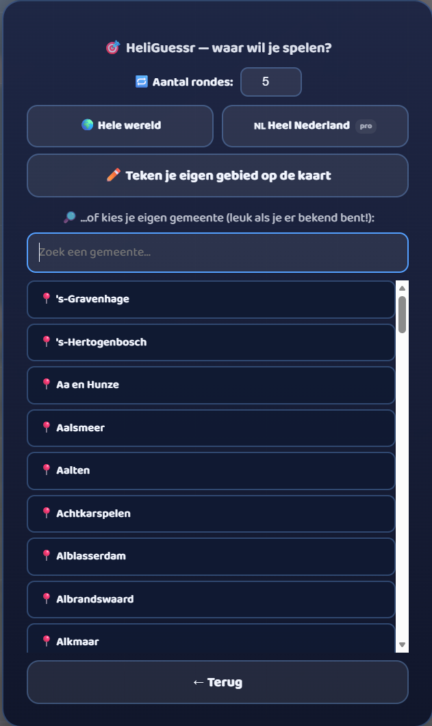
  • ๐Ÿ™๏ธ Your own municipality — choose from 342 Dutch municipalities; just type the name.
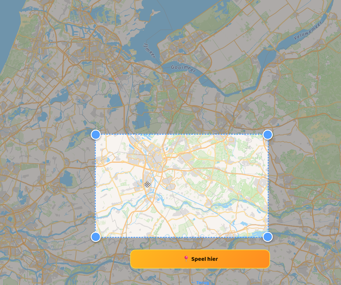
  • โœ๏ธ Draw your own area — drag a rectangle on the map with your finger or mouse and play exactly there.
HeliGuessr start screen: choose an area
Choose where you want to play

๐Ÿ˜๏ธ Play it in your own neighbourhood

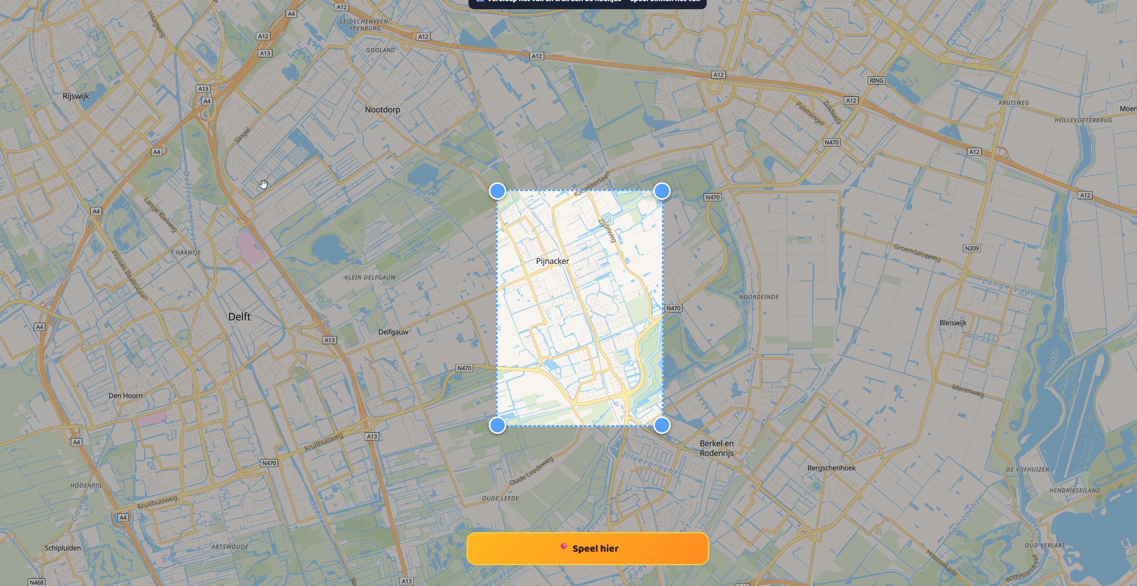
This may well be the very best part: HeliGuessr in your own neighbourhood. Draw a small area around your house, your school or your village, and you get street photos from right around the corner. Do you recognise the playground, the little square, the street where grandpa lives, the road to the football club?

Draw your own play area on the map
Draw an area around your own neighbourhood

And note: the smaller the area, the more the photos look alike — so close to home it gets surprisingly tough. That makes you really get to know your own surroundings: which street is where, how the neighbourhoods connect. After all, topography simply starts right on your doorstep.

Own area chosen on the map
Ready to play in your own city

๐Ÿค Playing together: HeliGuessr is multiplayer!

You can of course enjoy HeliGuessr on your own, but it really comes to life together. Here's how it works:

  • Create a game. You're the host: you choose whether you play all of the Netherlands or the whole world, how many rounds (1 to 10) and how much time everyone gets per round. You then get a short, easy code.
  • Play with your whole class. A game can handle up to 50 players at once — plenty for the whole group in one go.
  • Invite everyone. Share the code with one tap via WhatsApp, or forward the link. Whoever opens the link is straight in your game — no account or hassle needed.
  • Everyone gets the same photos. All players see exactly the same places in the same order, so it's fair.
  • Play against the clock. Each round runs a timer — nicely exciting, no one can dither forever.

Perfect for a birthday, a sleepover or a topo quarter-hour with the whole class: create a game and see who's the real neighbourhood or world expert.

๐Ÿ† How does the ranking work?

During and after a together-game, HeliGuessr tracks exactly who performs best — in two places:

The live scoreboard (while playing). On the side you see a list that updates continuously. Everyone is ranked by total score, high to low. Behind each name you see whether that player has already guessed the current round (โœ…) or is still flying (โœˆ๏ธ), plus their point total. Your own row is highlighted, so you see at a glance whether you're ahead or need to step it up.

The final ranking (when the game is over). Afterwards the result appears. The top three get medals — ๐Ÿฅ‡ gold, ๐Ÿฅˆ silver, ๐Ÿฅ‰ bronze — and below that everyone lines up at place 4, 5, and so on. Behind each player you see the final score. Is someone not quite done? Then you see “โณ Waiting for everyone to finishโ€ฆ” until the last one has completed their rounds.

And in a tie? If two players have exactly the same points, the one who is furthest along in the rounds comes top. So there's always a clear order.

A few examples of what such a ranking might look like:

  • ๐Ÿฅ‡ Fedde — 4,120 points
  • ๐Ÿฅˆ Noud — 3,880 points
  • ๐Ÿฅ‰ Tijn — 3,510 points
  • 4. Nienke — 2,990 points

Want to take on others across several games? In Topo Academy there's also a separate leaderboard based on how many places you master in total — but that's separate from a single HeliGuessr game.

๐Ÿ’ก Tips to guess better

  • Tap the photo to enlarge it. You can open the street photo full-screen to study small details — a street sign, a brand on a facade, a little tower.
  • Watch the landscape. Flat meadows with ditches and dead-straight roads? Good chance it's the Netherlands. Mountains, a different soil colour or different houses give away another country.
  • Read the road signs and number plates. Sign colours and shapes differ per country — a nice clue for world mode.
  • Use your freedom. You may fly anywhere before you guess — zoom in on the map, compare, and only then pick your spot.
  • Start easy. Play “all of the Netherlands” or your own municipality first before you dare take on the whole world.

๐ŸŽ“ What do you learn from it?

HeliGuessr is secretly very educational. You train your spatial insight: you connect how a place looks to where it lies. You learn map reading and keeping direction, and — if you play in your own area — you get to know your own neighbourhood, village or city inside out. It's exactly the kind of knowledge you never get from memorising a list: not just the name of a place, but also how it looks and how everything connects. And because you play it together, you practise without it feeling like “learning”.

๐Ÿš€ Where do you find HeliGuessr?

HeliGuessr is in Topo Arcade: log in, choose the ๐Ÿš€ Arcade world and you'll find it in the menu. It's completely free and ad-free. Have fun — and we're really curious what you think! Let us know via the “๐Ÿ’ฌ Idea or bug” button in the game. ๐Ÿš๐Ÿ’›

Read more โ†’

๐ŸŽ‰ New: the HeliGuessr update (version 0.3)

8 June 2026

Our biggest update yet! A brand-new game (HeliGuessr), playing together with friends, two worlds, your own school's topo method, a shop with coins and mouse controls on PC. Curious what you think!

Hold on tight: this is by far the biggest update to Toponauts yet. We spent weeks building it with great fun — a brand-new game, playing together with friends, two worlds to choose from and your own school's topo method. We're really curious what you think! Below we explain per part what it is and how it works.

๐ŸŽฏ HeliGuessr — guess where you are

Our brand-new game, inspired by GeoGuessr. You're shown a real street photo and then fly around freely with your helicopter — no arrow, no route, just you and the map.

How does it work? At the start of each round the game loads a random street photo from the area you chose. You only see that photo, with no place name. Look closely: do you recognise the landscape, a building, a typical Dutch road or a ditch? Fly to where you think the photo was taken and press “Guess here!”. The game then works out the distance between your guess and the real spot: the closer, the more points. After five rounds you see your total score.

HeliGuessr start screen
Choose where you play

Where do you play? That's entirely up to you: the whole world, all of the Netherlands, one of the 342 Dutch municipalities (just search for it), or you draw your own area on the map. And note: the smaller the area, the more the photos look alike — so it's precisely in your own town or village that it becomes a real challenge. Can you recognise your own neighbourhood from a random street corner?

Draw your own play area
Draw your own area on the map

๐Ÿค Play together — with your friends or class

Topo is even more fun together, and now you can do that in three ways:

๐ŸŽฏ HeliGuessr together. One player creates a game and gets a short code. You share it via WhatsApp or as a link. Everyone who joins gets exactly the same photos in the same order, so it's fair. While playing you see on a live scoreboard who's ahead, and when everyone's done the final ranking appears. Who knows their surroundings best?

๐Ÿ Race together. Create a race, share a short code and fly to the same places at the same time. Finding them faster and more accurately earns more points, with a live scoreboard too.

๐Ÿ‘ฅ You're not alone. While you simply practise you see other real players flying across the map as helicopters, with their pilot name underneath. No hassle and no chat — just pleasant company on the way. Prefer to practise quietly on your own? You can turn it off with one tap.

๐ŸŽ“ & ๐Ÿš€ Two worlds: Academy and Arcade

After logging in you choose where you want to go. That way you find what suits you right away:

  • ๐ŸŽ“ Topo Academy — here you learn: places, provinces, countries, capitals, flags, the learning line, tests and “recognise the place”.
  • ๐Ÿš€ Topo Arcade — here you play: Space, racing together, sailing and the new HeliGuessr — plus the shop with coins.

How does it work? It's not a separate account or separate progress: your XP, your level, your passport and your coins simply carry over in both worlds. You only choose where you start, and you hop from one to the other. Pupils joining via a class code stay neatly in the Academy — there learning comes first.

Choose Topo Academy or Topo Arcade
Choose your world after logging in

๐Ÿ“š Learn with your own school's method

Does your class use Argus Clou, Meander, Blink, Geobas, De Blauwe Planeet, Faqta or Wijzer? Or are you practising for the Cito? Under “Choose your method” you'll find exactly the right maps per method.

How does it work? Each method has its own set of maps, neatly ordered by area (the Netherlands, Europe, the world) and by school year — exactly the places that method covers. So at home you practise exactly what you get at school. And because Toponauts remembers per place how well you know it, the spots you still struggle with come back more often by themselves, while the places you've mastered are left alone. Smart practice, without you having to think about it.

Choose your topo method
Eight methods to choose from
Maps per method and area
The right maps per method

๐Ÿ›๏ธ Collect coins & shop in the store

For every place you find you earn a coin — in every mode. With your savings you shop in the store.

What can you buy? A different helicopter (from classic to a real UFO), your own colour, or real upgrades: Top speed makes your heli fly faster, Acceleration gets you up to speed sooner, and Turbo gives you a sprint as long as you hold the button. You buy them step by step, so there's always something to save up for. And no worries about unfair play: in the online race no upgrade counts — there everyone is exactly equal again.

The shop with vehicles, colours and upgrades
The shop

๐Ÿ–ฑ๏ธ Now playable with the mouse too

Playing on a laptop or PC? Besides the arrow keys (and touch on the tablet) you can now steer with the mouse too. How does it work? Hold the left mouse button and your helicopter flies towards where your cursor is — the further from the centre, the faster, just like a joystick. Release = brake. That way it plays just as smoothly behind any screen.

Enjoy the update! We built this with a lot of love and would really like to hear what you think — use the “๐Ÿ’ฌ Idea or bug” button in the game or send us a message via the contact page. ๐Ÿš๐Ÿ’›

Read more โ†’

Sound and music: how Toponauts comes to life

6 June 2026

Toponauts now really sounds the part: every vehicle has its own engine sound that moves with your speed, and cheerful music plays in the menu. You control it all โ€” volume, sound and music separately on or off. Free and ad-free.

Learning works better when it's fun โ€” and little makes a game as lively as sound. That's why we've invested plenty in sound and music in Toponauts. Not as a distraction, but as an experience: you now hear what you're doing.

Each vehicle its own sound

The helicopter sounds like a real helicopter, and the heavy army chopper rumbles a lot deeper. The engine sound moves with your speed: gentle hovering sounds different from full throttle ahead. So you feel the flying and hear it when you accelerate โ€” without looking at the controls.

Music in the menu

Cheerful background music now plays in the menu, so choosing and waiting is pleasant too. As soon as you take off the music stops on its own, so you can focus entirely on the map while playing โ€” and when you come back to the menu, it plays again.

You stay in control

Not everyone always wants sound โ€” in class or on the couch. So you control everything yourself: a volume slider, a general sound button and a separate music on/off button. And of course Toponauts stays free and ad-free.

Tip for parents and teachers: try turning the sound on while your child plays. It makes flying and recognising places that bit more exciting โ€” and more exciting often means: practising longer.

And there's more to come: soon we'll tell you about the extra atmosphere around a very special vehicleโ€ฆ but we're not giving that away yet. ๐Ÿš

Read more โ†’
๐Ÿ“ฐ

New in Toponauts: practice mode Capitals of the Netherlands

4 June 2026

With the new practice mode Capitals of the Netherlands, kids learn in a playful way which capital belongs to which province. They fly to the right spot themselves, while the city name only appears once they're really there.

Good news for kids practising topography and for parents and teachers looking for a fun way to make knowledge stick: Toponauts has a new practice mode, Capitals of the Netherlands. In this mode a child gets a task like: fly to the capital of Drenthe. The idea is then to fly to the right city yourself. The city's name stays hidden along the way, so kids can't simply read off the answer but really have to think and remember.

Why linking province and capital matters

At school kids don't just learn separate place names, but also connections within the map of the Netherlands. It's valuable to know that a province doesn't stand alone, but also has a capital that belongs to it. That linking of knowledge is exactly what makes topography stronger: not only where is it?, but also what goes with what?.

When kids learn that Assen belongs to Drenthe, Haarlem to North Holland and Zwolle to Overijssel, they build a solid geographic overview. That helps with topo tests, but also with reading comprehension, world orientation and following news or stories about the Netherlands.

Not a list by heart, but real practice

Many kids can memorise a list for a moment, but lose it again quickly afterwards. This practice mode works differently. Because the city name stays hidden until you're at the right spot, kids have to think actively: Which capital belongs to this province? Roughly where is it? That makes the practice much more powerful.

They don't just recognise the name, but also train their spatial insight and memory. So kids practise several skills at once:

  • linking province to capital;
  • recognising the location on the map;
  • actively recalling knowledge without ready-made hints;
  • building confidence by finding the right answer on their own.

Learning while you fly makes it fun

What makes this mode extra appealing is the playful approach. Kids aren't just filling in right or wrong, but really set off. They fly across the Netherlands and look for the right destination. That gives a sense of discovery and makes practising feel less like school, while they learn in a very focused way.

Great for home and the classroom

The new practice mode is handy at different moments. At home kids can practise independently as preparation for a test or just to get more familiar with the provinces and capitals of the Netherlands. In class it's a nice addition to the topo lesson โ€” as review, choice work or a short drill.

With Capitals of the Netherlands, Toponauts shows that learning topography can be clear, active and fun. Not by just looking, but by searching, flying and remembering yourself.

Read more โ†’
๐Ÿชช

New: choose your own pilot name

2 June 2026

From now on you choose a fun pilot name for in the game โ€” separate from the login name you sign in with. So your name can be funny and unique, and you'll never hit 'that name is taken' again.

We've made creating a profile in Toponauts more fun and easier. From now on you have two names, and that's on purpose:

1. Your pilot name

This is the name you see in the game โ€” above your helicopter, on the scoreboard and when racing together. It can be nice and fun, silly or cool: 'Captain Tijn', 'Dragon Boss', 'Superpilot'โ€ฆ anything goes. And the best part: multiple kids may have the same pilot name. No more 'that name is taken'!

2. Your login name

You use this to log back in later. It's unique for everyone, so the game knows who you are. No worries: Toponauts automatically makes a login name from your pilot name. If you're 'Captain Tijn', the game suggests for example captaintijn. You can keep it or change it yourself.

Why this split?

Kids love to pick their own cheerful name โ€” but for logging in it's handy if every name is unique. By separating the two, you get the best of both: freedom to be creative and a name that always works to log in.

Creating a new profile? You'll see the new steps automatically. Happy flying! ๐Ÿš

Read more โ†’

The topography game of old โ€” now perfected

31 May 2026

Many parents and teachers still remember it: that old topography game where you flew a helicopter over the map of the Netherlands to find places. We love that nostalgia โ€” and rebuilt the idea in Toponauts, all new and better.

Maybe you remember it from years ago: a simple topography game where you flew a little helicopter over the map of the Netherlands. The teacher asked for a place โ€” Groningen, Maastricht, Zwolle โ€” and you steered your heli to the right spot on the map and landed there. No complicated explanation, just flying, searching and learning. That very simplicity made it so fun and educational: you remembered places because you flew there yourself.

Why that game worked so well

Topography sticks better when you do it instead of cramming it from a booklet. By looking up a place on the map, you link the name to a direction, a neighbouring province and a spot in the country. That old helicopter game understood that like no other โ€” it turned practising topography into a little adventure.

What we did with it

At Toponauts we're big fans of that nostalgia. We took that same familiar idea โ€” flying a helicopter over the map โ€” and perfected it with modern tech:

  • A real, smooth map instead of a coarse picture: you glide smoothly over the whole of the Netherlands.
  • The game grows with you: the better you know a place, the less help you get. So you climb from beginner to master all by yourself.
  • Much more than the Netherlands: also the provinces, rivers, Europe and the whole world โ€” with countries, capitals and flags.
  • More vehicles: besides the helicopter also a boat and even space.
  • For the classroom: teachers can create a class and follow progress.

The same joy of play, now better

The core has stayed the same as that game of old: cheerfully flying and learning topography through play. Only prettier, smarter and completely free and ad-free. So a new generation enjoys the same fun we learned so much from back then.

Read more โ†’
๐Ÿ—บ๏ธ

๐Ÿ—บ๏ธ Our roadmap: what we're still building

29 May 2026

A look ahead: the modes and features on the planning โ€” and what kids learn from them.

What is a roadmap? A roadmap is our "map for the future": an overview of the things we plan to add, roughly in order. It's not a hard promise โ€” plans can shift or change based on what players, parents and teachers tell us โ€” but this is what we're working on now.

Toponauts grows every week. Here's what's on the planning, always with the same idea: fun to do and you really learn something from it.

  • โ›ต Build out Sailing โ€” shifting wind, hoisting/lowering the sail, more harbours and a sailing race. Educational: coastal topography, wind direction/compass and cause and effect.
  • ๐ŸŒ Around the world in 80 days โ€” a journey from city to city with little puzzles along the way. Educational: world geography, routes and distances, and the order of countries and cities across the globe.
  • โœˆ๏ธ Plane mode โ€” flying a passenger plane from airport to airport. Educational: big cities and airports, country names and how far places lie apart.
  • ๐ŸŽจ Make your own avatar โ€” put together your own little pilot. Educational: less topo, more fun and ownership โ€” kids keep practising longer and more often.
  • ๐Ÿž๏ธ River missions โ€” following a river for a stretch instead of flying to one point ("the news wants footage of the Meuse"). Educational: rivers run from somewhere to somewhere โ€” you learn their course, not just their name.

Got an idea yourself? The game has a "๐Ÿ’ฌ Idea or bug" button โ€” we read everything that comes in there. A big part of what Toponauts can do today started as a tip from a player, parent or teacher.

Read more โ†’

The Learning Ladder: from name to capital

27 May 2026

One world mode that automatically gets harder per country as you get to know it better.

The Learning Ladder world is our smartest way to learn the world. You start easy and climb up automatically โ€” and that happens per country separately.

  • Rung 1 โ€” Name: "Fly to France", with an arrow to help.
  • Rung 2 โ€” Flag: you only see the flag and find the country yourself.
  • Rung 3 โ€” Hint: only a clue, no more name.
  • Rung 4 โ€” Capital: "The capital is Paris โ€” fly to the country".

Every time you find a country correctly, Toponauts remembers it. That same country comes back one rung higher next time. That way you automatically link name, flag, capital and location โ€” exactly what sticks for a topo test โ€” and everything earns XP.

Why this works: you practise the same country through a different "entry point" each time โ€” name, the shape/colours of the flag, a hint, the capital. Your brain makes more connections that way, and the exercise adjusts itself to your level: easy where it can be, challenging where it needs to be. Ideal once you know the basics and are ready for the next step.

Read more โ†’
โ›ต

๐Ÿšง In development: Sailing with real wind

25 May 2026

No throttle button โ€” you sail on the wind. Hoist the sail, pick your course and sail from harbour to harbour. We're still building this mode out.

Note: this mode is still in development. The basics work โ€” but we're still tweaking the controls and adding more step by step. What you play now is an early version; expect improvements in the coming weeks.

In the Sailing mode you sail a boat along the Dutch coast and the IJsselmeer, from harbour to harbour โ€” with real wind physics. That makes it very different from flying: you don't brake with a button, but by easing your sail. Straight into the wind you barely move, so โ€” just like a real skipper โ€” you learn to tack: zigzagging to still get where you want. The wind vane at the top right always shows where the wind is blowing.

What we'll still add:

  • Wind that shifts and grows stronger/weaker, so you really have to watch the weather.
  • Hoisting and lowering the sail itself to speed up or slow down โ€” the arrows then become purely for steering.
  • More harbours and sea routes that unlock gradually, plus buoys and obstacles.
  • A sailing race against classmates over the same course.

Why this is educational: kids practise the location of the Dutch harbours and waters (coastal topography), while at the same time learning to read wind direction and compass and to think in cause and effect ("how am I positioned relative to the wind, and what happens then?"). That's spatial insight plus a first, playful taste of physics.

Tip for home: let your child explore the nearby harbours first. The play area grows by itself as they master more harbours, so it never gets too big all at once.

Read more โ†’

Race together with classmates

23 May 2026

Create a race, share the code and battle live to find all the places fastest.

Topo is even more fun together. In race mode you create a race and share a short code with your friends or classmates โ€” they only have to type in that code.

Everyone flies to the same places on their own screen, and on the live scoreboard you watch each other creep ahead. The faster and more accurately you find them, the more points you grab.

A perfect way to end a topo lesson: five minutes of fierce racing through the Netherlands or the world. Classroom tip: let the winner pick the list for the next round.

Why this is educational: under a little (friendly) time pressure you really have to find places from memory โ€” a much more active form of review than quietly practising. And because everyone gets the same places, you immediately see what you didn't yet know; those are exactly the spots you'll remember best afterwards.

Read more โ†’

Toponauts in the classroom โ€” for teachers

21 May 2026

Create a free teacher account, manage all your classes and see live who's practising.

Toponauts has a full teacher module. As a teacher you create one free account and manage all your classes with it โ€” no separate passwords to remember.

  • Class code: your pupils log in with a simple code and their first name. No email addresses, no hassle.
  • Live overview: you see who's online right now, each pupil's level and the average test scores.
  • Where is the class stuck? A list automatically shows the places the class struggles with most โ€” handy to review together.
  • Decide what's allowed: turn areas or modes on and off per class. Practise just the Netherlands for a bit? One tick.

Ideal for a topo quarter-hour in class, a weekly task, or as homework kids keep doing voluntarily.

Why this is handy in class: you see at a glance who's taking part and what the group as a whole still struggles with, so you can review specific things together instead of guessing. And because it mostly feels like play to children, they practise more than they would with a worksheet โ€” without it having to be called "learning".

Read more โ†’

Guessing flags & recognising places

19 May 2026

Two challenges that test your topo knowledge โ€” with real flags and photos.

Besides plain flying there are two fun challenges that feel a little different:

  • ๐Ÿšฉ Guess the flag: you're shown a flag and fly to the right country. Great for drilling the flags of Europe and the world.
  • ๐Ÿ“ธ Recognise the place: you see a real photo of a Dutch place and fly to it. Can you recognise it from a building, a bridge or the landscape?

The photos and flags are on our own server (originally from Wikipedia), so everything loads fast and works reliably โ€” even on the classroom tablet, with no ads in between.

Find a place or country and it simply counts towards your progress and your XP.

Why this is educational: with "Guess the flag" you link a symbol to a country and its location โ€” a handy memory hook. With "Recognise the place" you learn that a city is more than a name on the map: you connect it to how it really looks. Both train recognition from a different starting point than the bare name, which makes the knowledge more solid.

Read more โ†’

Travel around the world: 195 countries & capitals

17 May 2026

From your own village to the other side of the world โ€” step by step, ever further.

In Toponauts you don't just fly through the Netherlands. You travel the whole world in steps:

  • ๐Ÿ‡ณ๐Ÿ‡ฑ The Netherlands: cities, villages, all twelve provinces, rivers and nature areas.
  • ๐Ÿ‡ช๐Ÿ‡บ Europe: all the countries, capitals and the big rivers.
  • ๐ŸŒ The world: all 195 countries with their capitals, plus the continents.

For every country you find, you see the flag, hear a snippet of the anthem and read a short, kid-friendly fact. That combination of seeing, hearing and reading makes it really stick.

The world unlocks gradually as you get better, so a beginner isn't swept away by 195 countries all at once.

Why this is educational: because you fly to a country yourself, you learn not only its name but also where it lies, how big it is and which neighbours it has โ€” spatial insight you can't get from memorising a list. The flag, the anthem and the fact also turn it into a little story, and stories are simply easier to remember.

Read more โ†’

Smarter learning: the game grows with you

15 May 2026

Toponauts remembers how well you know each place and tunes the help to match exactly.

Toponauts remembers per place how well you already know it. A spot you're just learning gets lots of help โ€” an arrow, the name on the map and a generous landing zone. Once you know it well, that help disappears on its own, until you know the place completely by heart as a Master ๐Ÿง .

When you create a profile you pick a starting level (Beginner, Easy or Normal). You earn higher levels by playing โ€” so you never have to force anything and every child plays at their own pace. That keeps it fun and educational.

Curious how far you've come? In the Skill screen you see an honest meter of how much you really master โ€” and it drops back neatly when you start to forget something, so you know what to review again.

Why this works: this is "spaced repetition" in a form kids enjoy โ€” places you've almost forgotten come back just in time, and places you know well come back less and less often. That way you spend your practice time exactly on what's still needed, instead of endlessly repeating what you already know.

Read more โ†’

Welcome to Toponauts!

13 May 2026

A free topography game where you learn by flying, sailing and even going into space.

Welcome! Toponauts is a free topography game for kids. You fly a helicopter (or sail a boat, or head into space!) over a real map and learn places, provinces, countries, capitals, rivers and flags as you play โ€” from the Netherlands to the whole world.

No ads, no hassle, no email address needed. Make up a fun pilot name and you can take off right away. The game remembers your progress automatically, so you always pick up where you left off.

Over the coming weeks we'll expand Toponauts a lot โ€” keep an eye on this blog for new modes and tips. Play right away at toponauts.com. Have fun!

Read more โ†’

About Toponauts

Toponauts is a free, ad-free topography game for kids. You get to know places by flying or sailing to them with a vehicle โ€” actively and through play.

  • ๐Ÿ‡ณ๐Ÿ‡ฑ The Netherlands: cities, villages, provinces, rivers, lakes and nature areas
  • ๐Ÿ‡ช๐Ÿ‡บ Europe & ๐ŸŒ the world: countries, capitals, continents and rivers
  • ๐Ÿšฉ Recognise flags and ๐Ÿ“ธ recognise places from a photo
  • โ›ต Sailing, ๐ŸŒŒ exploring space and ๐Ÿ racing together

For the classroom: teachers create a free account and manage all their classes with it.

Made with โค๏ธ in the Netherlands.

โœ‰๏ธ Contact the maker

A question, an idea, found a bug, or just a message? Leave it here โ€” it goes straight to the maker of Toponauts. Fill in your email address if you'd like a reply.

Privacy

  • No ads. We only use anonymous, cookie-free visitor statistics (Umami, our own server) โ€” no personal data.
  • What do we store? Only what's needed to play: player name, encrypted password and progress. No email address or real name needed.
  • Classes: pupils log in with a class code and a first name.
  • Delete? You can always have a profile removed โ€” just ask.